

|
Magnolia Neighborhood Planning Council |
|
Planning for Magnolia’s Future Our Goal: Getting to “Yes!” |
|
Planning Coordinators: Shary Flenniken
Neighborhood Representatives: Bailey Park Neighbors
Bridge Crest Shary Flenniken
Carlton Park I Gretchen Taylor
Carlton Park II
Central Valley Bill Rasmussen
City View—South Amor Youngs
City View—North
Discovery Park Neighbors Ron Piland
Dravus Corridor
Land’s End Robin Budd
Magnolia Boulevard/Perkins Lane Neighbors
Magnolia Village Joan Abrevaya
Manor Place Candy Martin
Salmon Bay Neighbors
Thorndyke Business District
Thorndyke Corridor Neighbors Chris Wyrick
28th Avenue Corridor
Local Organizations: Discovery Park Advisory Group
Ella Bailey Park Stewards
Fisherman’s Terminal
Fisherman’s Terminal Industrial Council
Magnolia Bridge Advisory Group
|

|
“Magnolia Grande” |

|
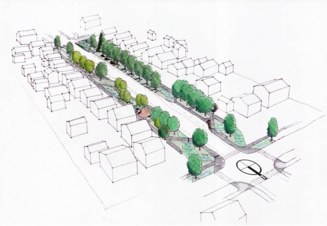
34th Avenue W Street Side Improvements |
|
In 2006 the City’s Seattle Public Utilities department, the University of Washington, and residents and friends of 34th Avenue West met over a period of several months and came up with a range of options and plans for creating low-impact storm water treatment solutions that utilized the parking strip areas that run along the street sides.
How can we make streets function at their highest ecological and social levels, with the least cost and fewest obstacles? This is the challenge that Seattle Public Utilities (SPU) hoped to meet, using Magnolia’s long connective arterial, 34th Avenue West as its testing ground. This street was selected due to its exceptionally wide "parking" strips (aka planting strips) to play with; its underlying water and habitat connections between Elliot Bay and the Ship Canal at the Ballard Locks; and its primacy as a social connector between a community and its institutions. The territory hosts the largest heron rookery in the state, adjoins the wilds of Discovery Park, incorporates the commercial village of Magnolia, and takes in senior housing, churches, and an elementary school, library, park and community center. SPU's mission here was broad education effort that will hopefully affect the practices of individuals to cumulatively impact resource conservation. The City and utility's responsibilities encompass water conservation, stormwater management and treatment, habitat protection and enhancement, climate protection, and waste reduction. This branch of SPU focuses on garden practices, particularly pesticide use reduction, composting, soil amendment, proper plant selection, water re-use, and community cohesion, and we will incorporate those practices in our broader design work. UW students working on the project helped residents to understand the project, its local watershed and neighborhood context, and then helped to characterize the various typical street conditions. At the end of the workshops prototypical proposals for treatment of the street-scape, storm water runoff, and, especially, parking strips that address pedestrian and bicycle transportation, rainwater harvest, stormwater detention and treatment, urban forestry, community art and markers, and habitat features and ecologies were created. Models for residential, business, and civic land uses, were merged into a master plan for the whole of the street, and quantification of the potential benefits in terms of air, water and earth resource protection were made. The prototype work was designed to be adaptable to more limited situations (e.g. narrower parking strips), and alternative solutions that range from minimal interventions that residents can easily undertake, to structural proposals that would require collaborative citizen initiative and/or City sponsorship (though SPU's interest is primarily in the low-hanging-fruit solutions) were also created.
|
|
34TH AVENUE WEST RESIDENTIAL PROJECT AREA |